They've got the best pectoral fins out there.
One reason it occurred to me to discuss our sculpin populations is the appearance of this recent news item:
http://news.yahoo.com/big-headed-fish-species-discovered-idaho-montana-rivers-201333579.html
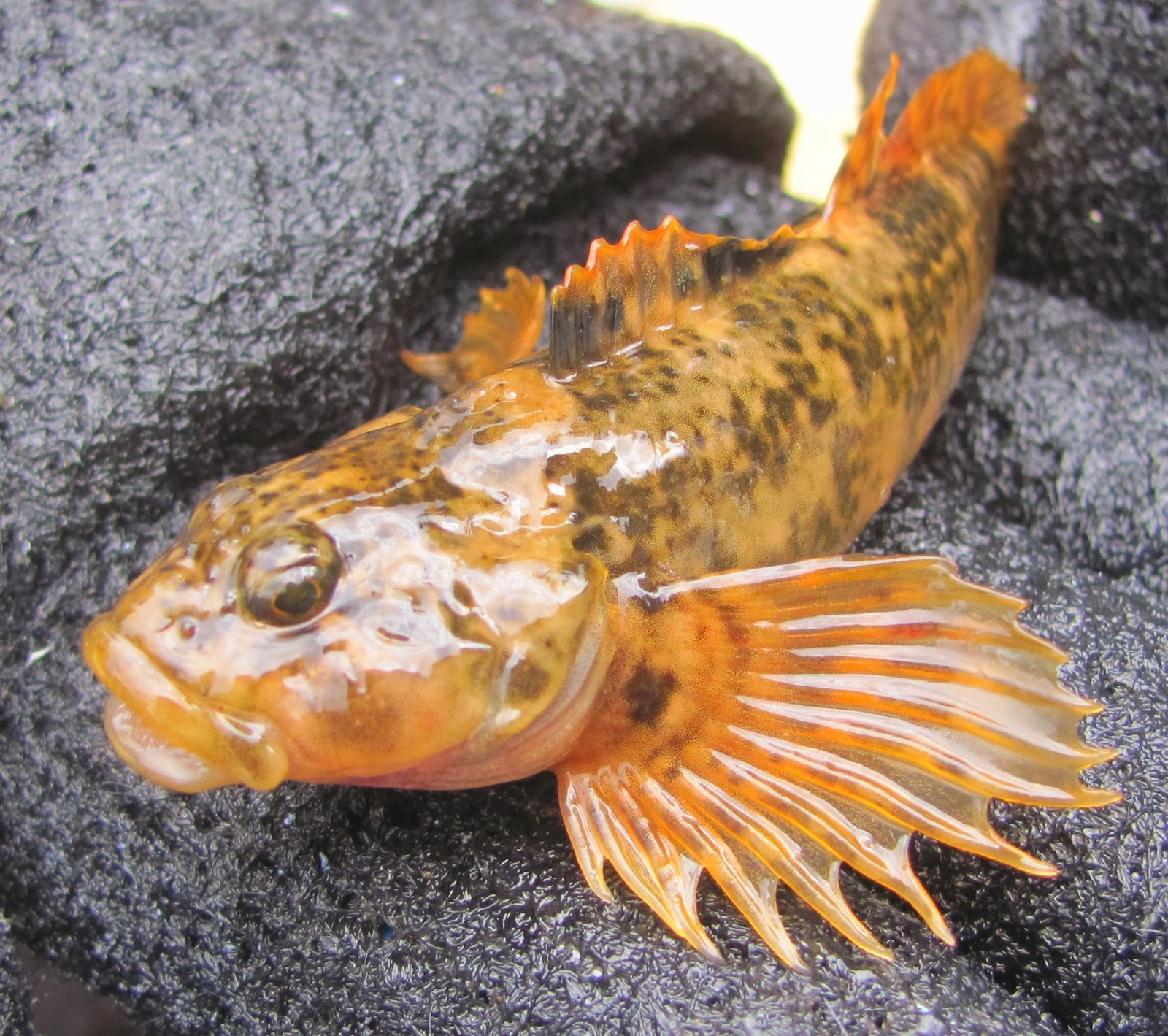
It is always interesting when a new species is described, and the news media picks up on it to say that it has been "discovered." It makes it sound as if no human has ever seen the fish before. The reality is, anglers and biologists have likely handled these fish untold thousands of times; it's just that this is the first time that they were examined genetically. I'm certain that something very similar would happen if we closely examined our sculpin species in Colorado. We would probably have at least one new named subspecies or species. Right now, we've got two that we know about; paiute sculpin (Cottus beldingi) and mottled sculpin (Cottus bairdi). Some of the sculpin from waters in Grand County have been keyed out as paiutes, which is only possible in a lab. The bottom line is, we don't know the exact distribution of the two species, if they overlap, if there is hybridization, or if there is at least another subspecies that is unrecognized. There has been talk that the sculpin in the Eagle River may constitute their own subspecies. For simplicity's sake, what is important is that they're a native fish, and on the upper Colorado we've always referred to all of them as mottled sculpin.
We've found some interesting patterns in their distribution at the headwaters of the Colorado River. Below is a map depicting a simplified version of the distribution pattern:
.bmp)
The green lines I've drawn here represent streams that have sculpin populations, and the red lines represent streams where sculpin are absent. We have found that almost without exception, we have dense populations of sculpin upstream of every impoundment in Grand County, and the absence of sculpin below every impoundment. It is astounding how consistent this pattern is. Last September I was able to add the Muddy Creek watershed to this map, after doing some sampling on private land upstream of Wolford Reservoir and finding high numbers of sculpin there. There are zero sculpin in Muddy Creek below Wolford. Williams Fork, Windy Gap, Willow Creek, and Granby - all these reservoirs have dense sculpin populations upstream and no sculpin downstream.
On the Fraser River in the town of Granby, sculpin are by far the most numerous fish species. In 2012, in a 600-foot reach of river there, we collected 1,279 sculpin, and they constituted 83% of the fish we captured. That yielded a population estimate of at least 20,000 fish per mile. Moving downstream past Windy Gap, to the mainstem of the Colorado River, at the Hitchin' Post Bridge, we have searched the riffles there every year for sculpin and found zero. This is only about four miles from the site on the Fraser in Granby, and the species that is most plentiful in the first site is completely absent from the second site.
Sculpin reappear in the Colorado River at some point below the Blue River confluence. At Pumphouse, they are very dense again, and are again the most numerous fish species present.
We don't know the precise reasons for this distribution pattern, but we would like to. It's not an overstatement to say that there has to be a massive ecological shift that takes place over short geographical distances to produce such a contrast.
On a positive note, there is some movement toward mitigation work taking place on the Colorado as part of ongoing negotiations with the water providers. It's looking likely that Windy Gap will be re-engineered somehow to become an off-channel reservoir, and that a bypass will be built. Also it looks like there may be a pool of money that becomes available to to a lot of physical habitat work in the river from Windy Gap on down. We'll see.
I gave an update recently at a meeting of the Snake River Watershed Task Force in Keystone. If you're not familiar with the Snake River, it's an interesting place. It's got by far the most polluted water of any stream in the area. A lot of the metals pollution comes from the Peru Creek drainage, where there are old mines releasing acidic water laden with high concentrations of metals that are lethal to fish. If you're at all interested in water chemistry, Peru Creek is a fascinating place. You can walk up the stream and the bed of it is an ever-changing rainbow of colors, based on which metal is precipitating out of the water in that particular reach. There are white sections, red sections, greens, blues - lots of different shades.
Below is a map, courtesy of my USGS colleague Andrew Todd, depicting where in the Snake River watershed we have fish living in streams and where we have no fish at all. The blue sections are where there are fish, and red is where there are none:
.bmp)
Below Peru Creek, the only reason that any fish can live in the Snake River at all is the dilution that is provided by the North Fork, coming down off of Loveland Pass. The amount of relatively clean water coming from that drainage dilutes the metals pollution just enough to allow some trout to persist below that point. However, it's not exactly a high-quality trout population.
We have a survey site, right along the base of Keystone, that we sample every year to check on the status of the fish population and it tells some interesting stories. The brook trout numbers tell us the most, because those fish are never stocked or manipulated in any way -- if they're there, they got there on their own. Here is the population estimate for brook trout on that reach going back to 2007:

These numbers are estimates of the total number of brook trout inhabiting the 500+ foot reach that we survey. It's not extrapolated out to fish per mile or anything. So you can see, this is a distressed fish population and this river teeters on the edge of even being suitable for fish at all. The reason why there are two samples in 2007 is that there was a flash flood from a cloudburst that hit the Peru Creek basin in late July of that year. We had already surveyed the site before the flood. We had reports from the public that there had been a fish kill during the flood. We went back a month after the flood and electrofished again, and saw that the flood had wiped out the brook trout population, and in fact it wasn't until three years later, in 2010, that we even saw brook trout there again. And, as you can see, the brook trout population has never returned to pre-2007 flood levels.
Keystone Resort purchases and stocks rainbow trout annually in this reach of river. They buy them at a large size, and they do provide entertaining fishing for the tourists. I wondered if we get any holdovers at all from year to year among those rainbows, and so in 2008 I started adipose-clipping all the rainbows that we handled in the survey section. This way, we can see whether or not any of those stocked rainbows survive a winter there. Below are those results:
r.bmp)
So, out of the 46 fish that we marked in 2008, we captured 5 in 2009, for 11% survival, and so on. 2012 and 2013 have been particularly rough in this respect. For this data, fish emigrating out of the reach counts the same as mortality. Whichever happens, it's obviously not very hospitable there.
The good news about the Snake River is that after a couple of decades of effort and attention, there is a broad coalition of entities (EPA, US Forest Service, USGS, Summit County, etc.,) starting to clean up the mines of Peru Creek. It has taken a huge amount of concentrated effort and searching for funding. There is real momentum now and in 2013 quite a bit of underground work was done to figure out what it's going to take to clean up some of the most polluted water. So, hopefully in future years we'll see those metals concentrations drop and a healthier fishery develop.
It looks like there are sculpins between Shadow Mountain dam and Granby. What makes that stretch of river different than those below the other impoundments?
ReplyDeleteGood question Dan, I was wondering if anyone would point that out. I believe that the reason why we have sculpin below Shadow has to do with the operation of Shadow Mountain Dam. First of all, let's assume that the reason why sculpin are present or absent has something to do with the occurrence of intense flushing flows on a regular basis that clean out large cobble/small boulder habitat and maintain the interstitial spaces in the bed of the river. Shadow Mountain is not a storage reservoir per se. It's basically a glorified canal that conveys water from the Granby pump canal to Grand Lake and the Adams Tunnel. During spring runoff periods of normal years, there is a large volume of water flowing into Grand Lake and Shadow Mountain from surrounding tributaries. Usually at this time of year, Northern Water is collecting plenty of water from the east slope into their storage on the east side (Carter and Horsetooth) that they're not even taking water through the Adams Tunnel -- they have no place to put it. During these times, Shadow "disappears" hydrologically -- meaning, it's full, and whatever runs in through Grand lake and tributaries, runs out of Shadow dam. Therefore, the reach of river between Shadow and Granby experiences somewhat of a normal, intense peak flow. The same is not at all true for the Colorado below Granby Reservoir, because Granby is the storage vessel, and captures that runoff volume. Granby has such a huge capacity for storage that it is rare for it to spill - only once a decade or so.
DeleteThis is probably more of a hypothetical question--would moving Windy Gap off the main channel really improve the runoff flow situation in the Colorado? They will still have to fill the reservoir. And even if it does, is there enough flow coming through the Fraser to have the desired impact? If so, it would benefit stonefly nymphs as well as the sculpins.
ReplyDeleteDan, the Windy Gap bypass doesn't address QUANTITY of water at all. It will address water QUALITY issues that occur when the water spends time sitting in Windy Gap before moving on down the river. It gets warmed up in the reservoir and picks up a lot of algae, excess nutrients, etc. Windy Gap is a shallow pan all the way across, so that water just sits there cooking in the sun. It's kind of a petri dish. It will also restore connectivity for fish to move into and out of the Fraser and/or upper section of the Colorado to Granby Dam, if they're inclined to do so. Based on anecdotal information and some stuff I've seen on the ground, I have a suspicion that during the glory days of the wild rainbow fishery, that the lower end of the Fraser played a significant role in recruitment of rainbows to the mainstem - that spawning fish moved in & out of the lower Fraser. We do see really good juvenile fish production from the mouth of the Fraser canyon down - including some rainbows. So reconnecting the Fraser with the mainstem so that fish passage is possible will certainly be a positive thing. Water QUANTITY is being addressed in a completely different set of agreements, which have been mostly driven by Grand County. There are some significant volumes of water that are going to be added to the river to help fill some of the holes that we have at critical times of the hydrograph and that is going to help a lot.
DeleteAlso - I forgot to mention that the river bed below Windy Gap is mostly made up of large cobble that has been there forever, and silt. A dam like Windy Gap interrupts the sediment transport process and the river is really lacking a steady supply of pea-size to tennis-ball-size gravel, and that substrate is important in maintaining the health of a river like the Colorado. So a bypass will restore that process also.
DeleteHey Jon,
DeleteGood information on sculpins. My current feature for SW Fly Fishing is the Yampa, my home river. Sculpin patterns, the Muddler Minnow in particular, seem to work well in pea size to tennis ball clean cobble. Hope your doing well. Ken Proper
When man interrupts nature it is hard to achieve balance.
ReplyDeleteTrying to undo,creating a bypass ,could also have an reverse effect.
One, allowing more sculpin predators,to hunt sculpin.
Two,any reason man doesn't know,ie. That fish know,such as metal pollution, etc.which could be nlocked(in settleing) in dams. All,I'm saying is one needs to be careful,interrupting,what's been done.undoing is good ,or is it what was the populations of sculpin in those stretches before dams etc?